Harvesting the wind’s energy sounds like a straightforward task. Hoist a rotor into the air and its blades rotate, turning the attached generator, which produces electricity; the windier the selected location, the more electricity generated. Wind, however, is not just wind.
WIND MEASUREMENT ADVANCES
Harvesting the wind’s energy sounds like a straightforward task. Hoist a rotor into the air and its blades rotate, turning the attached generator, which produces electricity; the windier the selected location, the more electricity generated. Wind, however, is not just wind. It is a powerful swirling force that bounces off objects in its path, accelerates through valleys, decelerates across plateaus, varies in intensity over the ups and downs of undulating landscapes and reacts both imperceptibly and violently to changes in temperature and pressure. Collecting wind measurements that provide meaningful data for analyses is a largely unsolved challenge in the wind power industry. But a discovery by researchers at the wind division of Denmark’s technical university (DTU) is being heralded as a breakthrough that promises to advance wind turbine design, wind turbine micro-siting and wind farm optimisation.
The more the wind’s turbulent patterns are understood, the better a wind turbine can be designed to withstand the huge and varying loads it is subject to while keeping material use to a minimum to save on construction costs. As important for achieving the overall aim of high productivity — at least cost — is to know where to precisely place each wind turbine in relation to the effect its surroundings have on the wind, including the effect of other turbines. In addition, if wind patterns across a wind farm can be mapped in fine detail, each and every turbine’s geometry can be adjusted to maximise the operational efficiency of the entire plant over its full working life.
Fundamental advance
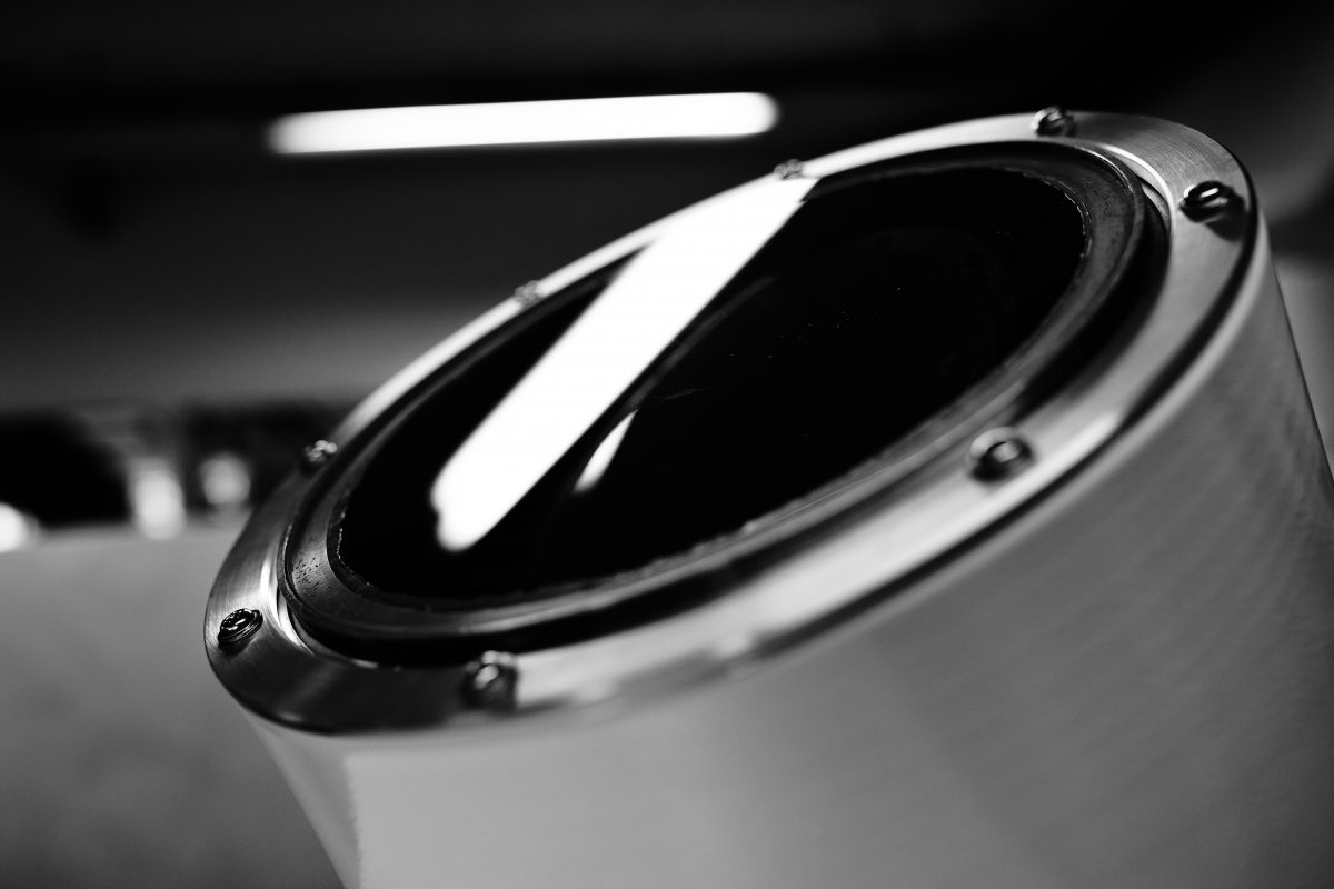
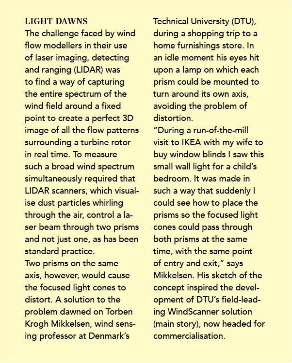
What has been missing from the science of wind assessment is a way to precisely create three dimensional images in real time of spatial wind flows as they approach and pass through a turbine rotor, both close up and at a distance. The solution to this problem devised by the DTU team is a fundamental advance in the use of laser imaging for wind detection and ranging, commonly known as LIDAR. “It’s a huge leap on the way to full understanding of what the wind does at the heights of today’s modern wind turbines. Other places in the world are working on this type of technology, but DTU is the first to have made a serious breakthrough,” says Henrik Stiesdal, a highly respected wind engineering pioneer and former CTO at Siemens Wind Power. LIDAR provides information on wind speed and direction by capturing and measuring the light reflected from particles of dust as they whirl through the air to create 3D wind maps. Portable LIDAR units have been increasingly used in the wind industry over the past 15 years as an alternative to the installation of meteorological masts equipped with spinning anemometers. Once wind turbines grew so tall that wind measurements at heights of more than 100 metres became a regular demand, deployment of equally tall met masts became ever more impractical. LIDAR units came into their own.
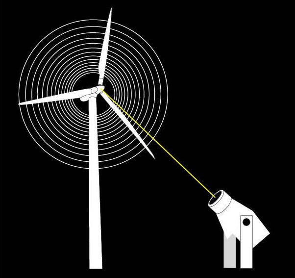
For all the advantages of LIDAR, however, the apparatus has only been able to measure speed and direction from one place at a time using a single scanner. The wind could be measured in front of a wind turbine or behind it, but not both and not from all directions. DTU’s solution, dubbed WindScanner, advances the technology by using up to three scanners.
[caption id=“attachment_6462” align=“alignnone” width=“1024”] 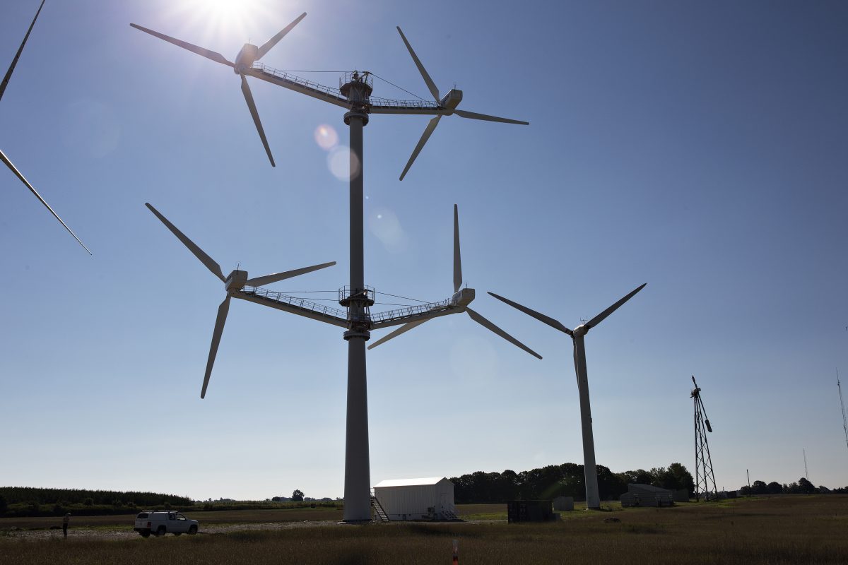 OUT ON A LIMB. At the forefront of wind technology development is the discovery by Denmarkʼs technical university of how to visualise the entire wind spectrum as it passes through a rotor. DTU researchers can now give Vestas a far better understanding of how its experimental multi-rotor machine reacts to self-generated turbulence— and whether the turbulence is a help or a hindrance to overall performance. ˮA huge leap,ˮ says wind engineering pioneer Henrik Stiesdal (right), about the latest advance in wind measurement science.[/caption]
The big difference
“Our challenge was to find a way of coordinating and controlling several laser beams to move synchronously while pointing in the same direction at the same place. That enables us to measure the whole wind field, which is what is different about our technology,” says DTU’s Torben Krogh Mikkelsen. When data from three scanners is combined, wind speed, wind direction and turbulence can be measured to create a perfect 3D image of the otherwise invisible wind. The DTU team has now developed a range of WindScanner models, from a 3D short range device with a reach of over 150 metres that takes several hundred scans a second to a long range WindScanner that takes fewer scans, but can measure the wind at distances of up to ten kilometres. Work is ongoing to stretch that reach to up to 30 kilometres, particularly useful for the offshore wind industry.

Instead of a wind tunnel
The WindScanner is being put through its paces in a research programme comparing several LIDAR technologies for offshore use being run by the UK’s Carbon Trust, a public-private body set up to drive advances in energy and climate technology. The apparatus is also part of an EU research initiative supported by the European Strategy Forum on Research Infrastructures. In Denmark, a WindScanner is doing duty at the DTU Risø Campus wind turbine test site, replicating the kind of detailed information on the wind’s interaction with its test subject that would previously only have been possible to achieve in a wind tunnel using a scale model. Full scale measurements in real life conditions also add a new dimension to research work. Among the turbines being tested at Risø is an experimental multi-rotor concept from Denmark’s Vestas, which suspends four refurbished 225 kW nacelles on arms jutting from a single tower. It is similar in concept to other such experiments, including the Dutch Quadro design from 1988 that was operated in the Netherlands for well over a decade. Thanks to the WindScanner, the complex wind streams created by the four rotors of the Vestas machine can now be visualised, potentially allowing the concept to be developed to the point of commercial viability.
For the WindScanner to reach maturity and commercial viability, it has to be both cheaper and more robust to withstand everyday treatment by engineers. “That’s not a step that DTU can take on its own. It’s up to the wind industry to help out by pressuring suppliers of the apparatus into seeing the commercial perspectives in industrialising it for use by wind turbine manufacturers and wind farm developers,” says Stiesdal. •
TEXT Berit Viuf, Lyn Harrison / PHOTO Lars Just